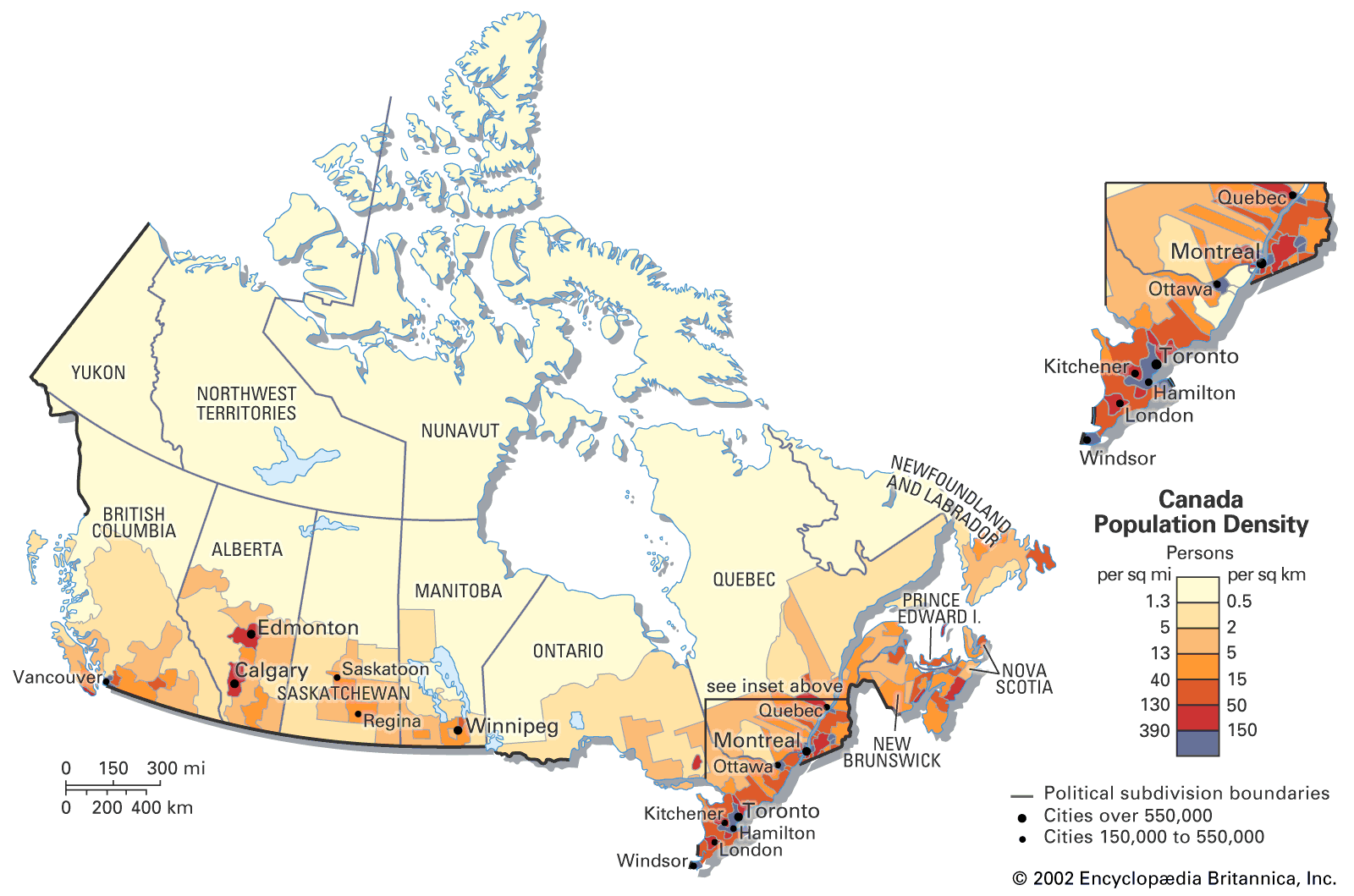
Legitimate question: what may be the actual reason for this concentration? Is it weather? Natural resources? Is it political? On a related note: what is the reason that Canada as a whole has so few people? It is still mindblowing for me that the entire country has less people than each of the world’s top 3 metropolitan areas
Also this map is kinda misleading. Edmonton and the entire 4 maritime provinces are not here, and the main reason so much of the population is close to the border is that something like 1/3 of the population is clustered around the great lakes/st Laurence, because people came here by boat.
The great lakes area was the first area extensively settled and thus has the most developed cities. The great lakes area is also rich in fresh water and farmland.
I’d argue the weather as the biggest one, at least for BC. Northern BC is absolutely beautiful but it’s cold af in the winter and burny as hell in the summer. If we’re talking far north in the territories, I know another issue is infrastructure because it’s much more difficult to build/get stuff up there. Though this meme misses a big part of the Indigenous/Inuit population that lives up there.
Also, this country is just fucking huge, like bigger than I think any of us realize. If our population were to spread out, it would be a very thin spread.
Edit: I kept thinking about this and got help with some math on it. If the population of Canada were to spread out, we’d each have about 64 acres (0.256km) to ourselves. By comparison, the same calculation in the US with the US population would equal approx 0.03 km, or just over 7 acres per person.

Legitimate question: what may be the actual reason for this concentration? Is it weather? Natural resources? Is it political? On a related note: what is the reason that Canada as a whole has so few people? It is still mindblowing for me that the entire country has less people than each of the world’s top 3 metropolitan areas
deleted by creator
Also this map is kinda misleading. Edmonton and the entire 4 maritime provinces are not here, and the main reason so much of the population is close to the border is that something like 1/3 of the population is clustered around the great lakes/st Laurence, because people came here by boat.
The great lakes area was the first area extensively settled and thus has the most developed cities. The great lakes area is also rich in fresh water and farmland.
50% of our population is below the 49th parallel. 90% is within a half a day of the southern border
for reference:
Further south is warmer in winter
But I think a lot of it is economic. Port cities are where money changes hands, and we’ve effectively smeared them all along the boarder.
I’d argue the weather as the biggest one, at least for BC. Northern BC is absolutely beautiful but it’s cold af in the winter and burny as hell in the summer. If we’re talking far north in the territories, I know another issue is infrastructure because it’s much more difficult to build/get stuff up there. Though this meme misses a big part of the Indigenous/Inuit population that lives up there.
Also, this country is just fucking huge, like bigger than I think any of us realize. If our population were to spread out, it would be a very thin spread.
Edit: I kept thinking about this and got help with some math on it. If the population of Canada were to spread out, we’d each have about 64 acres (0.256km) to ourselves. By comparison, the same calculation in the US with the US population would equal approx 0.03 km, or just over 7 acres per person.